Access Projects
Find out what projects the South Downs National Park Authority is currently supporting to enable better access for people to enjoy the beautiful countryside within the Park.
Click on the title below for more details about Access projects we are currently supporting, which partners we are working with to deliver the projects and how these projects meet the outcomes of our Partnership Management Plan. You can also see where in the National Park these Access projects are on our interactive map (indicated in dark blue).
For case studies and details of past Access projects, click here.
- Centurion Way Extension
The Centurion Way is an 11km (6.8 miles) cycling and walking path between Chichester, Lavant and West Dean, and has since extended to Cucumber Farm. It follows the old, dismantled Chichester to Midhurst railway line, which was fully closed by 1991 and the name is based on the fact that the path crosses the course of a Roman road.
The route extension is being completed in stages and each section will be opened when it’s safe and practical to do so, with a view of connecting the Centurion Way with the South Downs Way National Trail.
The first section of the extended route opened on Saturday 23 August 2025.
- Beggars Bush Walk For All, Community Nature Area
The aim of this project is to upgrade existing Public Rights of Way (PROW) and permissive paths and the creation of a new Permissive route, including:
- Creating increased opportunities for circular walks to and from the urban fringes
- Enhancing the visual landscape – remodelling of unofficial parking area
- Expanding, enhancing and connecting key habitats – chalk grassland, hedgerows and rough grass margins
- Creating opportunities for community engagement through hedgerow planting and ongoing management
- Providing opportunities for interpretation of the NP, farmed landscape and cultural heritage
Supporting farming operations through stakeholder engagement and installation of fencing and kiss gates to aid recreation management
Partners: Sompting Estate & Sompting Parish Council
PMP outcomes: 1.1 (Protect Landscape Character), 1.2 (Create Green Infrastructure), 3.1 (Join up Habitats), 4.1 (Conserve Heritage), 5.2 (Improve accessibility), 7.1 (Improve Health and Wellbeing), 8.1 (Increase Volunteering).
- Egrets Way project – summary
 February 2026
Egrets Way is an SDNPA priority scheme initiated in 2011 by a group of local residents to create a safe, largely off-road segregated shared-use path between the county town of Lewes to the Port of Newhaven. The route is approximately 7 miles / 11km long following the course of the River Ouse and crosses the South Downs Way National Trail at Southease.
With Kingston Downs on the western side, Firle escarpment to the east, the Egrets Way offers an accessible shared path for cyclists, mobility vehicle users and walkers amidst a picturesque and protected landscape.
Egrets Way is almost complete, with planning and landowner discussions on-going for Phase 7, the final section at Piddinghoe. Discussions are also on-going to address a short section of unsurfaced bridleway north of Southease.
Partners: Walk Wheel Cycle Trust (formerly Sustrans) and the Egrets Way Project community group. You can find out more about the Egrets Way Project community here.
For full project details and up-to-date information about the consultation for Phase 7, visit this page.
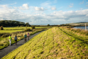
- Miles without Stiles
The Miles without Stiles initiative is all about improving access to the South Downs for people with limited mobility. By identifying routes without steps, stiles and steep gradients and by carrying out improvements to path surfacing and access furniture we working to make the South Downs one of the most accessible National Parks.
 To date we have replaced more than 30 stiles with gates improving access for wheelchair users, families with pushchairs, dog walkers and less agile walkers and created six Miles without Stiles route guides available to download here.
We are grateful to Gatwick Airport and the Friends of the South Downs who have provided funding to support for this work, and to the South Downs Volunteer Rangers who have installed many of the new gates.
You can download walking leaflets here.
Partners: Gatwick Airport and Friends of the South Downs
PMP outcomes: 5.2 (Improve accessibility)
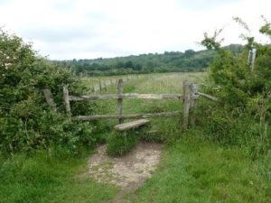
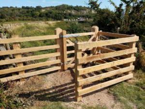
New Gate at Amberley, West Sussex on path 3502 (before and after):