Short and moderate walks
Spending time outside, even for just a few minutes a day, can do wonders to our mental and physical health.
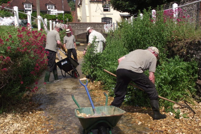
We’ve pulled together a selection of shorter walks, ideal for people of all ages and abilities.
East Sussex
- Charleston
Charleston is the Sussex home of the Bloomsbury Set, group of writers and artists, whose members included Virginia Woolf. The walk around Charleston offers visits to the landmarks and places that inspired the group.
- Cooksbridge and Lewes – Rail to Ramble
Two circular walks starting from either Cooksbridge or Lewes Railway Stations.
Enjoy downland views and the winding River Ouse or discover the historic market town of Lewes.
Complete the loops independently or merge to form one longer route of approximately 10 miles (15-16km).
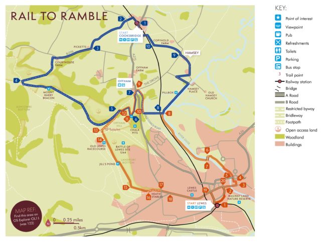
Cooksbridge Rail to Ramble
Distance:6.6 miles (10.7km) to loop back to Cooksbridge
Allow: 3.5 hours
Path: Uneven, sometimes muddy. Take care crossing roads and the railway line. A number of stiles/gates.
Gradient: Steep incline to Black Cap, one fairly steep descent to Offham.- Exit Cooksbridge Railway Station, turn right and immediately right again on the footpath parallel to the railway. Cross the stile into the field and head towards the stile in the roadside hedge. Turn left here and almost immediately right over a stile. Follow the path alongside the hedge.
- Turn right over a small stream then cross the field to a stile, heading towards farm buildings. Go over two stiles to cross a farm track and then head across a field towards another stile. Turn left here towards the B2116.
- Turn right passing Picketts to the path through the trees, up wooden steps and along the verge, carefully crossing the road opposite Courthouse Farm. Go through the gate and immediately right along the track, through another gate, turning left and then bearing right, climb steeply to (National Trust) Black Cap.
- Turn left along the grassy ridge, passing Mount Harry beacon. Go through a gate and bear right down towards a gap in the hedge. With the fence to your right pass through another gate.
- Keeping the fence on your right, zig zag right and then left (or if you are extending this walk and heading to Lewes, turn right and follow orange points 12 – 20). At the metal gate turn right and follow the path through woods to a kissing gate. Continue to the chalk pits bearing right until you reach the information board overlooking the chalk pit plateau and Lewes.
- Retrace your steps and turn right down the path, through a kissing gate. Keep right, cross the former chalk pit (Treacle Mines) and follow the sunken path, down past a wooden barrier and over a stile, to reach the A275 and the village of Offham.
- Turn left and carefully cross the road, turning right with Offham church on the left. Fork right on to a track which winds down through trees. After about 500m turn left through a gate. Continue, going through the gate and under the railway bridge and a further gate to reach the River Ouse.
- Turn left and follow the embankment to Ivors Lane. Turn left and take the footpath 200m on the right, keeping the hedge on your right. Pass between houses (narrow) and turn left on to Whitfeld Lane until you reach a T-junction with the Drove.
- Turn right then take the footpath on the left. Walk across the field towards a hedge gap. Continue with the hedge to your right to the railway line.
- Turn right towards a stile and carefully cross the railway line (stop and look both ways before crossing). Go right to a small bridge over a stream. Continue between houses, cross Malthouse Way and follow the gravel path leading to the main road. Turn right back to Cooksbridge Railway Station.
Lewes Rail to Ramble
Distance: 5.75 miles (9.3km) to loop back to Lewes.
Allow: 3 hours
Path: Uneven, sometimes muddy. Take care crossing roads. Multiple stiles.
Gradient: Steep incline to Offham chalk pits. Some of the streets in Lewes are steep.- Exit Lewes Railway Station and cross the bridge. Turn right along Landsdown Place and Friars Walk, over the mini roundabout until you meet the traffic lights. Turn right into the precinct.
- Continue over Cliffe Bridge until you get to North Court (a small alley way on the left).
- Go through the alley and follow the brick pathway passing Harvey’s Brewery.
- Continue along the brick path winding left to meet the river Ouse.
- Follow the riverside walk passing Tesco on your right until you reach Willey’s Bridge.
- Cross the bridge.
- Turn right and follow the river bank passing through three gates until you reach a railway bridge.
- Head away from the river under the bridge towards the woods. Pass through a gate, turn right and take the woodland path up to Offham village.
- Turn left at the main road (A275) then right onto the footpath by Toll Cottage. Take the left fork and head up a steep path to Offham chalk pits.
- Keeping left, cross the chalk pit plateau. Climb the hill through the kissing gate.
- Turn left here for the information panel and view above the main chalk pit, or right to continue. Go along a wooded path and turn left at the iron gate.
- Pass through a wooden gate, and following the path over the field, cross another path, until you come to the gate in the corner of the field.
- Pass through the gate and the next gate, crossing the road by the old racecourse.
- Keeping the fence on your right, head down around Jill’s Pond, to the gate at the bottom of the hill.
- Here, there is an information board about Landport Bottom and the Battle of Lewes. Continue downhill to the tarmac road.
- Stay right, following the path. Continue past Heath Stables to the main road.
- Carefully cross the road on to Spital Road and continue downhill towards Lewes Town Centre
- Stay on the left pavement meeting Western Road. Continue on, passing the Greenwich Meridian plaque in the pavement, to the centre of Lewes.
- Turn right down Station Street towards Lewes Railway Station or to see more of Lewes continue past the War Memorial bearing right down (steep) School Hill to the traffic lights at the bottom.
- Turn right here to retrace steps 1 and 2 to head back to Lewes Railway Station.
Points of interest
Mount Harry BeaconIn use between the 16th and 19th centuries, the beacon was lit as part of a south coast defence system, warning local militia of potential invasion. The current brazier was erected to celebrate the Golden Jubilee of Queen Elizabeth in 2002.
Offham Chalk pits
A hive of industrial activity during the 18th and 19th century. Here, the raw chalk of the South Downs and the River Ouse meet and both were part of the great chalk pit and lime industry which has shaped the landscape we see today.
Battle of Lewes 1264
The Battle of Lewes, where Simon de Montfort defeated King Henry III, took place on Offham Hill in 1264. This, along with the battle of Evesham the following year, helped to pave the way for our modern parliamentary system.
Lewes Castle
Built shortly after the Norman invasion to dominate and control the Sussex coast. Royal forces encamped here before engaging in the Battle of Lewes. The castle was later used as a prison and a warehouse for wool.
Harvey’s Brewery
The oldest independent brewery in Sussex. A family business for seven generations since John Harvey in 1790. Visit harveys.org.uk to find out more about this delicious locally brewed beer.
South Downs National Park
From rolling hills to bustling market towns, the South Downs National Park’s landscapes cover 1,600km² of breathtaking views, hidden gems and quintessentially English scenery. A rich tapestry of wildlife, landscapes, tranquillity and visitor attractions, weave together a story of people and place in harmony.
For your guide to everything there is to see and do in the National Park visit southdowns.gov.uk/discovery-map
Keep up to date with the latest news events from the South Downs National Park. Sign up to our monthly enewsletter, southdowns.gov.uk/newsletter
Your Countryside code: Respect. Protect. Enjoy.
Respect other people
- Leave gates and property as you find them
- Keep to the paths unless on Open Access Land
Protect the natural environment
- Take your litter home
- Keep dogs under effective control
Enjoy the outdoors
- Plan ahead and be prepared
- Follow advice and local signs
You can find this route on ViewRanger
Download the free ViewRanger app from your app store. Once registered you can search for South Downs National Park to view all of our routes. All our routes on ViewRanger are available for FREE – you do not need to buy any maps to view our walks and rides.
Getting there
By bus: There are regular services to Lewes, Offham and Cooksbridge, visit traveline.info/se
By rail: Southern hourly service 7 days a week between London and Eastbourne stops at Cooksbridge and Lewes. Visit nationalrail.co.ukTake the Lead
For a safe and fun visit with your dog please remember to keep them on a lead around livestock and wildlife. Always bag and bin your dog poo – any public bin will do!
Contact
South Downs National Park Authority: 01730 814810
@SDNPA /SDNPA southdownsnp
southdowns.gov.uk - Ditchling Beacon & Devil’s Dyke
Two of the highest points on the South Downs Way, Ditchling Beacon and Devil’s Dyke both promise stunning panoramas of the low Weald and North Downs.
- Hamsey
The villages of Cooksbridge, Offham and Hamsey sit in the East Sussex parish of Hamsey. Here you can discover a variety of landscapes ranging from high chalk downland, the water meadows of the Ouse and the heavy clay pasture and woodlands of the Low Weald. There are great viewpoints from the top of Offham Chalk Pit and on the approach from the Ouse Valley.
- Heritage Coast Walks
Seven Sisters Country Park comprises 280 hectares of chalk cliffs, a meandering river valley and open chalk grassland. Named after the famous Seven Sisters that form part of the chalk cliffs on the Sussex Heritage Coast, one of Britain’s finest unspoilt coastlines, it is a great place to explore.
- Lewes & Southease
Walking the Glynde route, you can see Mount Caburn hill fort and National Nature Reserve, Glynde Place (an Elizabethan mansion), plus panoramic views of the South Downs National Park, Ouse Valley and Lewes.
On the Southease and Lewes Brooks route, enjoy the path along the River Ouse and see the delightful villages of Rodmell and Southease including their interesting churches. The South Downs way section provides beautiful views.
- Ouse Valley
Southease and Rodmell are typical downland villages. Southease, the smaller of the two, boasts a tiny 12th century church. Rodmell also has a Norman church, and nearby you can visit Monk’s House, the country retreat of writer Virginia Woolf, now owned by the National Trust. In both villages you’ll find delightful thatched cottages, plus Rodmell is also home to a thriving village pub – the Abergavenny Arms.
- Plumpton
This walk will take you through diverse woodland habitat and chalk streams, as well as the opportunity to see the picturesque church in East Chiltington.
- Rottingdean
Walk in the footsteps of Rudyard Kipling, who first stayed in Rottingdean as a young boy before deciding to settle in the village as an adult. This walk will take you through the small part of the ‘whale-backed Downs’ Kipling adored.
- Stanmer Park & the Chattri
Discover the beautiful woodland walks of the Stanmer Estate and visit the Chattri Memorial, commemorating the Hindu & Sikh soldiers that served in the First World War.
- Telscombe and Mill Hill
Take time out and explore the picturesque village of Telscombe. The village has retained its peaceful character due to the wealthy bookmaker Ambrose Gorham who left the village to a trust known as ‘Gorham’s Gift’.
- In Their Footsteps app
We’ve teamed up with partner organisations in this quaint part of East Sussex to launch a new immersive walking experience across three cultural venues.
The ‘In Their Footsteps’ app is a self-guided audio tour, with walks from Charleston Farmhouse, Monk’s House and Ditchling Museum of Art+Craft.
You can download the App from your phone’s app store:
- Play Store: http://bit.ly/InTheirFootstepsGoogle
- Apple: http://bit.ly/InTheirFootstepsApp
Hampshire
-
- East Meon
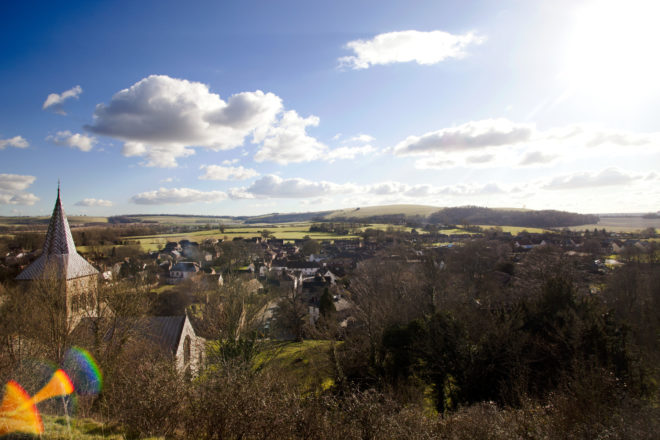
The picturesque village of East Meon, once owned by the Bishops of Winchester, is home to many historic buildings including the Old Court House. There are a couple of pubs offering delicious local food and a village shop for essentials. The walks in this leaflet start at the imposing Norman church of All Saints with its magnificent spire which was added in 1230. Pop inside the church to see its beautiful, medieval font.
Above East Meon and Up to the Downs
These walks take you across chalk streams, over downland and onto the South Downs Way.
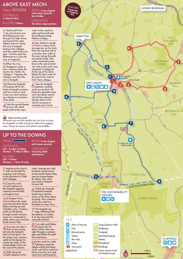
Download the printable leaflet
River Meon
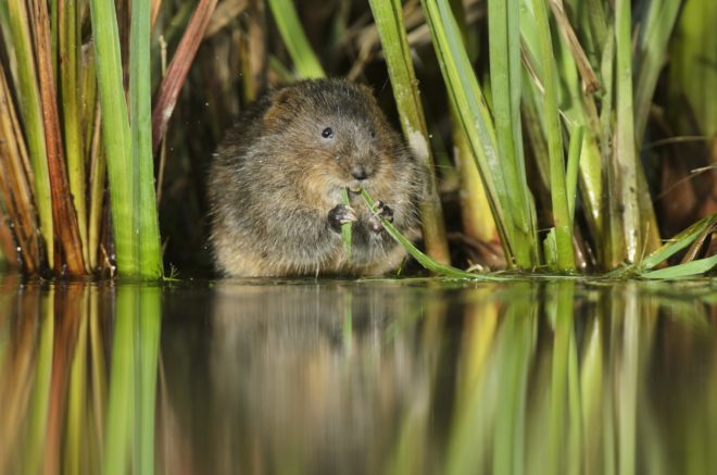
Filtered by the chalk of the South Downs, the crystal clear waters of the River Meon flow for 21 miles down to the Solent. At South Farm you’ll see one of the sources of this beautiful river known as ‘the Swift one’. Providing a rare and precious habitat for an array of species, you might be lucky enough to spot otter and kingfisher. The river supports a good population of fish too such as wild trout, minnows and brook lamprey.
The Meon Valley Partnership
The Meon Valley Partnership (MVP) was created in 2008 to help improve the condition of the River Meon. Working with volunteers and local people the MVP have been part of a number of projects including re-introducing water voles in the Meon Valley. Recorded as locally extinct in 2003 they are now thriving and have been recorded at 30 locations along the River Meon from source to sea, including at East Meon. The partnership have also been involved in naturalising the river by narrowing it to create pools and flow deflectors to generate places for fish to hide from predators and keep the river cool. Plants have been added to the riverbanks to increase biodiversity, attracting insects, birds and small mammals. Examples of this can be seen through the centre of East Meon village.
South Downs Way
Stretching the entire length of the South Downs National Park, this 100 mile national trail runs from the historic city of Winchester to the white clis of Beachy Head at Eastbourne. The section of this trail in these walks gives you stunning views out over the quintessential English, rolling countryside.
Take the Lead
For a safe and fun visit with your dog please remember to keep them on a lead around livestock, horses and wildlife. Always bag and bin your dog poo – any public bin will do!
Getting here
By bus: Regular services from Petersfield and Winchester, visit traveline.info/se.
By rail: The nearest train station is Petersfield, visit nationalrail.co.uk.Contact
South Downs National Park Authority: 01730 814810
Twitter: @SDNPA
Facebook: /SDNPA
Instagram: southdownsnp - Cheriton and the River Itchen
One of the three main sources of the River Itchen lies just to the south of Cheriton. The Itchen is considered to be one of the best chalk rivers in Britain with its crystal clear waters filtered over thousands of years through the porous chalk of the South Downs.
Renowned for the quality of its fly fishing, access is restricted to the river and few footpaths run along its banks. Fortunately, within a three-mile stretch of the upper Itchen, five footbridges cross the river – this leaflet shows you how to make use of them to create a lovely circular walk. Don’t forget your binoculars to spot lots of wildlife on the river.
- Haslemere and Fernhurst
This walk takes you to the highest point in the South Downs National Park, Blackdown. Standing at 280 meters, it is only second to Leith Hill (295 meters) in the South East of England. The walk will also take you onto the Serpent Trail, a 100km trail that snakes through some of the most remarkable lowland heath in England.
- Haslemere – rail to ramble
As well as being a charming market town, Haslemere offers an important gateway to the South Downs National Park. The walks begin at Haslemere Railway Station and follow roads, lanes, tracks and footpaths to finish either in Liphook or Liss.
- Liphook and Milland
Discover the remnants of an iron-making era here in the South Downs National Park. The proximity of Milland to London and the coast, with the existence of iron ore, charcoal and water, meant this now peaceful landscape was once overcome by the sounds and smells of the iron-making trade.
- Meon Valley Trail
Discover a trail that leads you through English history. Once a railway line running from Fareham to Alton transporting local livestock and agricultural produce, the trail now spans 11 miles through picturesque countryside, from West Meon in the north to Wickham in the south.
- East Meon
- St. Hubert’s Church, Idsworth
Known as ‘The Little Church in the Fields’, St. Hubert’s Church dates back to 11th century.
Surrounded by a wildflower meadow planted by SDNPA rangers, the church also contains medieval wall paintings, making it a very unique and special place to visit.
Download the walking leaflet of St. Hubert’s and the Idsworth Valley
West Sussex
- Amberley
Amberley is a chocolate box village with many old buildings, thatched cottages, a castle (now a private hotel), a church, two pubs and a shop. There is also a working pottery. You can clearly see where the River Arun carved out its channel through the chalk. Nowadays flood banks confine what was once a wild and wandering river.
- Arundel
Originally built at the end of the 11th century by Roger de Montgomery, Earl of Arundel and one of William the Conqueror’s most loyal barons, Arundel Castle was badly damaged during the civil war. The gothic style castle was restored in 1900 and is considered to be one of the great works of Victorian England.
- Centurion Way
The Centurion Way is a 6.8 mile (11km) cycling and walking path that starts in Chichester, passing through Lavant and West Dean to finish at Cucumber Farm in Singleton. It follows the course of the old Chichester to Midhurst railway line, which closed in 1991.
The name, Centurion Way, was suggested by a local schoolboy and is based on the fact that the path crosses the course of a Roman road.
Further extensions are planned to link the Centurion Way to the South Downs Way National Trail in Cocking.
View the Centurion Way route map here. This will be updated as the route is extended.
- Findon
Cissbury Ring, just north of the coastal town of Worthing, is one of the jewels in the crown of the South Downs National Park. It’s the largest hill fort in Sussex and has a history dating back over 5,000 years. Chanctonbury Ring is one of the most prominent landmarks along the South Downs Way. The ring is an Iron Age hill fort which is best known for the beech trees which dominate the site.
- Lavington and Duncton
Enjoy a beautiful circular walk in the landscapes around Lavington Common and Duncton Mill that inspired Ivon Hitchens. Painting in the open air around his Sussex home, Hitchens sought to capture the essence of the place and the resulting paintings, featuring swathes of bright colour, brought him international acclaim and a place in museums and collections around the world.
- Midhurst
The magnificent Cowdray ruins dominate the water meadows in the thriving market town of Midhurst and were visited by Henry VIII and Elizabeth I. Their existence today, thanks to restoration following a devastating fire in 1793, give many clues to life in Tudor times.
- Rogate and Harting
Explore the patchwork fields of Rogate and the sublime, peaceful River Rother on this walk that also takes in South Harting, home to St. Gabriel Church, a major landmark of the Rother Valley.
- Shoreham-by-Sea
Discover the peaceful countryside and stunning views of the Adur Valley. Mill Hill has excellent views across the Adur river valley, providing a great place for exploring and watching wildlife.
- Singleton
Explore open, hilltop pastures, sheltered nature reserves and the downland villages of Singleton and Charlton.
- Steyning, Chanctonbury and Washington
Steyning town is rich in history, with scores of timberframed buildings in and around the ancient high street. It was once a port on the River Adur and was prized by the Normans; their legacy today includes the magnificent parish church and the ruins of the castle in nearby Bramber. Visit some of the many shops, restaurants, pubs and tea rooms, or pop by for the monthly farmers’ market.